
Viewing a Geocache
Tap any cache to open its detail screen — the single place that gathers everything you need to find it: the essentials, the full description, the hint, recent logs, photos and waypoints.
The Essentials
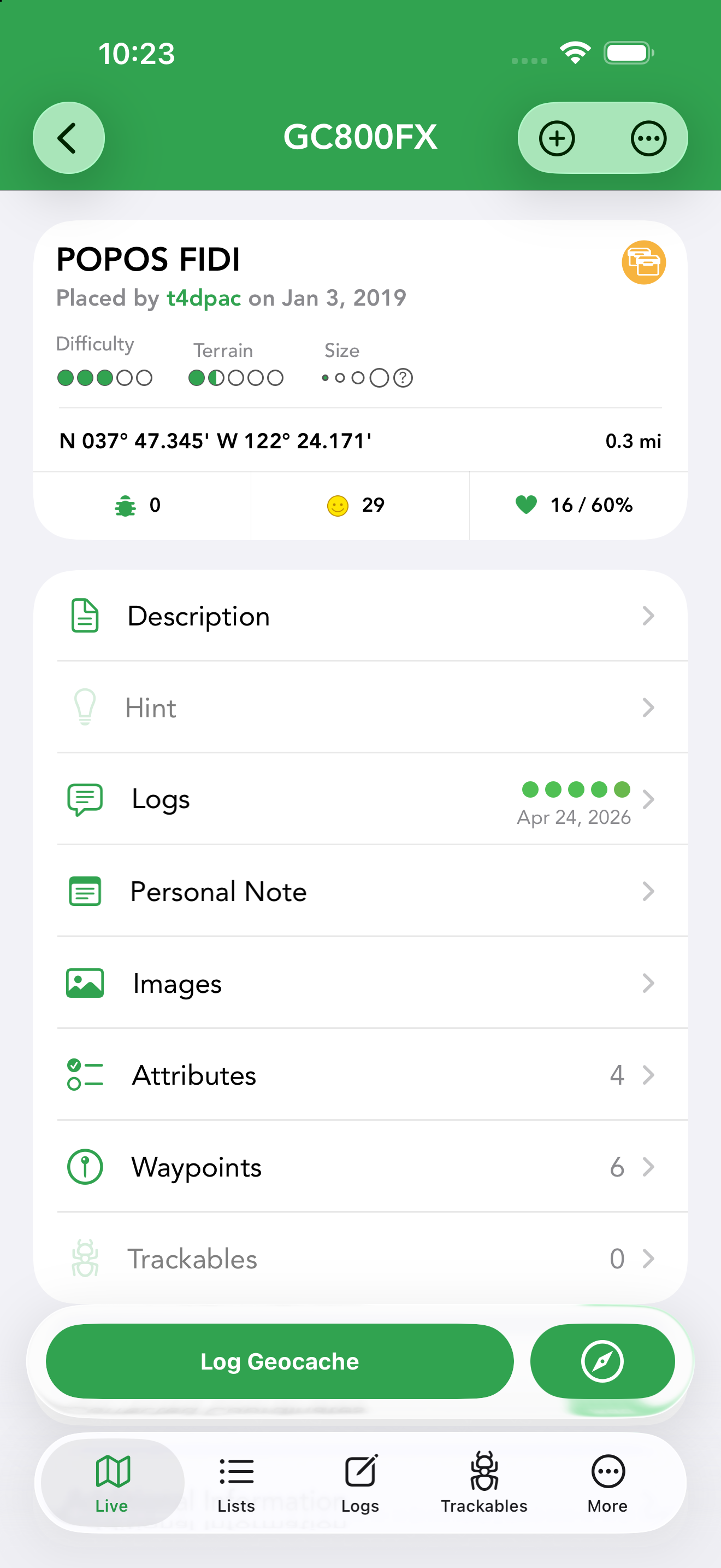
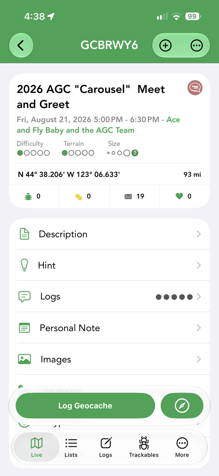
The top of the detail screen shows the cache’s identity at a glance: its name and code (GC…), who placed it and when, its type icon, difficulty and terrain ratings and container size. Below that sit the cache’s coordinates with your current distance to it, plus three quick counters: trackables in the cache, the cache’s find/happiness score, and its favorite points. On an event cache the counters read a little differently: the middle one counts the people who have logged Attended, and a fourth counter sits right beside it with the number who have logged Will Attend — a quick read on how big the turnout is likely to be.
- Tap the favorites count to see the users who awarded the cache a favorite point; if you’ve already found the cache, long-press it to award a favorite point.
- Tap the placed-by name to open that user’s profile.
- Tap the cache icon to see your own logs for this cache; long-press the middle finds area for My Logs and Friends Logs.
- Long-press the cache code in the title bar to copy it.
- Tap the coordinates to cycle through display formats; long-press them to copy.
The rest of the screen is a list of sections — Description, Hint, Logs, Personal Note, Images, Attributes, Waypoints and Trackables (rows show a count where useful, e.g. “Waypoints 6”) — followed by Corrected Coordinates, List Membership (the offline lists this cache belongs to) and Additional Information. Pinned to the bottom are the Log Geocache button and the round navigate button, so logging and navigation are always one tap away.
Viewing a cache also hands its name and location to iOS as a suggestion, so recently viewed caches can surface in Spotlight search, Siri Suggestions and Apple Maps — tap one to jump straight back to the cache in Cachly.
Cache Types & Icons
Cachly recognizes every geocache type on geocaching.com — 20 standard types plus Adventure Lab — each with its own colored icon on the map and in lists. The full set:
| Type | Notes | |
|---|---|---|
 | Traditional Cache | A container and log at the posted coordinates. |
 | Multi-cache | Two or more stages leading to the final container. |
 | Mystery / Unknown Cache | Puzzle caches; the posted coordinates are rarely the final. Supports Cachly’s solution checker and corrected coordinates. |
 | Letterbox Hybrid | A geocache that also contains a letterboxing stamp. |
 | Virtual Cache | No container — you verify a visit to a location. |
 | EarthCache | A geological lesson at a real-world site. |
 | Webcam Cache grandfathered | Capture yourself on a public webcam. |
 | Wherigo Cache | Played with a Wherigo cartridge. |
 | Event Cache | A gathering of geocachers at a set time. |
 | Cache In Trash Out (CITO) Event | An environmental cleanup gathering. |
 | Mega-Event Cache | A large event (500+ attendees). |
 | Giga-Event Cache | A very large event (5,000+ attendees). |
 | Community Celebration Event | Groundspeak community celebration gatherings. |
 | Geocaching HQ | The Geocaching HQ location in Seattle. |
 | Geocaching Block Party | The annual HQ block-party event. |
 | Geocaching HQ Celebration | HQ anniversary and milestone celebration events. |
 | GPS Adventures Exhibit | A museum GPS-adventure exhibit. |
 | Project A.P.E. Cache grandfathered | The remaining caches from the 2001 movie promotion. |
 | Locationless (Reverse) Cache grandfathered | Find an object matching a description, anywhere. |
 | Adventure Lab | Location-based Adventure Lab experiences. |
The same type icon appears in your lists and, as an inverted teardrop pin, on the map — with small decorations layered on to show your progress and each cache’s status.
In a list, an icon can show corrected coordinates, a prior DNF, a First to Find opportunity, a find you haven’t logged yet, or a cache you own:
 Corrected coordinates (red triangle)
 Prior DNF with corrected coordinates
 First to Find (FTF) available
 Found but not logged
 A cache you own
On the map, a pin can additionally show your find/DNF status, ownership, FTF and lonely flags (each toggled in Settings), event timing, and archived or disabled caches:
 Found by you
 Your DNF (did not find)
 A cache you own
 FTF available (indicator on)
 Lonely cache (indicator on)
 Event happening soon
 Unpublished event
 Found but not logged
 Archived Multi-cache
 Selected pin, corrected coordinates
 Archived / disabled cache
Disabled and unpublished caches also show a strikethrough on the name in list and detail views.
Description
The full listing description offers three viewing modes, and Cachly remembers your preference:
- Text — a clean standardized format with links and images.
- Web — the web-rendered version, useful when text formatting misbehaves.
- Source — the raw HTML, handy for puzzle caches that hide clues in the markup.
The options menu adds Translate with Google and print, and the sparkle button summarizes a long description with Cachly Intelligence. Coordinates found in the description are tappable for quick actions such as Create Waypoint, Set as Corrected Coordinates, Copy Coordinates and Navigate.
Hints & the Solution Checker
The owner’s hint is stored encrypted (ROT13) and Cachly decrypts it for you only when you open the Hint screen — so you won’t spoil yourself by accident. If a cache has no hint, the row is grayed out on the detail screen. For mystery/puzzle caches, Cachly includes a solution checker that verifies your proposed final coordinates, confirming you’ve solved it before you head out. Cachly uses Geocaching HQ’s official checker — the same one built into the cache’s geocaching.com listing — not a third-party checker such as Project-GC or Certitude. The Check Solution button appears at the bottom of the Description screen only on caches whose owner has set up the geocaching.com checker; caches that rely solely on a third-party checker don’t show it.
Recent Logs & Photos
Recent logs from other cachers tell you whether the cache is healthy and give hints about the hide. Each entry shows the log type icon and date, the finder’s name with their find count, badges for logs voted Great Story or Helpful, and a photo count when images are attached. The photo gallery shows images attached to the listing and to logs; downloaded caches keep their photos available offline.
The cache’s logs screen has three buttons in its top bar — sort, a person menu (My Logs or Friends Logs on this cache, using your geocaching.com friends) and filter. Filter opens a Filter By screen listing the geocaching.com log types (Found it, Didn’t find it, Write note, Attended, Will Attend, Reviewer Attention Requested, Owner Attention Requested, Event Announcement, Owner Maintenance, Enable, Disable, Archive); tick as many as you like to show only those. The filter button turns solid while a filter is active, and Clear in the top left removes the selection. It’s the quickest way to see just the DNFs on a cache before deciding to go after it, or to pull up the owner maintenance history.
Images
The Images gallery shows photos from the listing and logs in a grid grouped by date — including the listing’s background image when the cache has one; tap one for the full-screen viewer with save and share, and swipe through. When a photo came from a log, the viewer’s ⋯ menu adds View Log: it opens that log on its own screen — author, full text, date and images — so you can read the story behind a photo without hunting through the logs list. (Fetching the log needs an internet connection.) For offline caches you can Download Current Images, Download More Images (fetch additional photos from geocaching.com), or Delete All Images to reclaim space.
Personal Notes
A personal note stores your own info about a cache — up to 2,500 characters — and the text syncs with your geocaching.com account. Notes found in a GPX file can be kept or merged during import. Cachly detects coordinates you type into a note; tap them for quick actions: Create Waypoint, Set as Corrected Coordinates, Check Solution (for caches with a checker), Copy Coordinates and Navigate.
Notes support Markdown. The editor’s Edit / Preview control at the top switches between writing and reading: in Edit, the syntax is highlighted as you type — headers grow bold, **bold** and *italic* take effect, links tint, inline code switches to a monospaced font — and in Preview the note is fully rendered, with headers, bold, italic and links formatted. Coordinates and @usernames stay tappable in the preview, and saving always keeps your raw Markdown text.
The ⋯ button next to Save offers Insert Waypoints: every user waypoint of the cache is inserted at the cursor as a Name: coordinates line (sorted by name). It’s a quick way to get solved stages or a puzzle final into the note — where they sync to geocaching.com and benefit from coordinate detection.
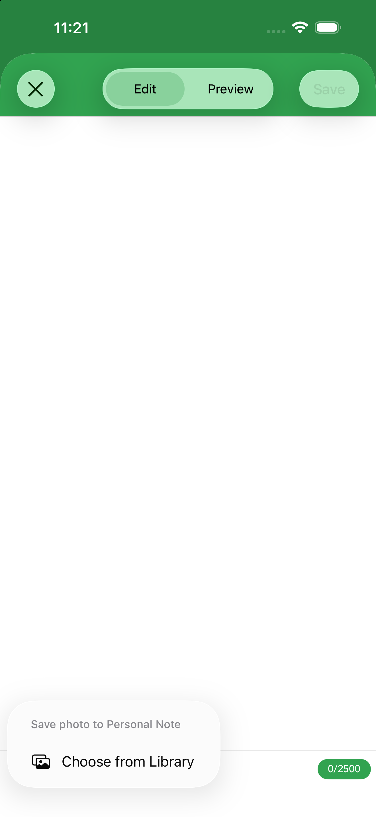
The + button at the bottom left of the note editor attaches photos to the note — take a photo or choose one from your library. This requires iCloud and iCloud Drive to be enabled for Cachly; attached images are stored under the cache’s GC code, so they sync to all of your devices running Cachly and are also available in the iOS Files app in a folder named for that GC code.
Attributes
Cache attributes summarize conditions and requirements — Available at all Times, Stealth Required, Field Puzzle, Tourist Friendly, and so on. The Attributes screen lists them in plain language with their icons so you can plan before you go.
Waypoints
The Waypoints screen starts with the cache’s Original Coordinates and then lists its additional waypoints — parking, trailheads and the stages of a multi, each with its own description and coordinates — along with any user waypoints you add yourself with the + button (including projections). See Waypoints & Coordinates.
Waypoint pins use their own symbols. Cache waypoints carry a type that sets the pin; your own user waypoints are shown in blue, and a small bar adds the waypoint number (P0, P1…) when a cache has more than one of a kind:
 Parking
 Trailhead
 Reference Point
 Final Location
 Physical Stage
 Virtual Stage
Trackables in the Cache
The Trackables row shows how many Travel Bugs and geocoins are currently in the cache. Open it to see each trackable with where it was last seen; tap one for its full details. To grab or discover a trackable, use the log flow when you log the cache.
Corrected Coordinates
Corrected coordinates mark a cache’s real/final location — common on Mystery, Wherigo and Multi-caches — and sync automatically with geocaching.com. A corrected cache shows a red triangle on its pin and its coordinates in green at the top of the detail screen; by default it’s shown at the corrected spot. To view original locations instead (e.g. for Geo Art), enable Settings › Caches & Waypoints › Ignore Corrected Coordinates (the triangle then shows a question mark) — you can also reach this from the map by long-pressing the layers button and choosing Options. Corrected coordinates can be removed at any time.
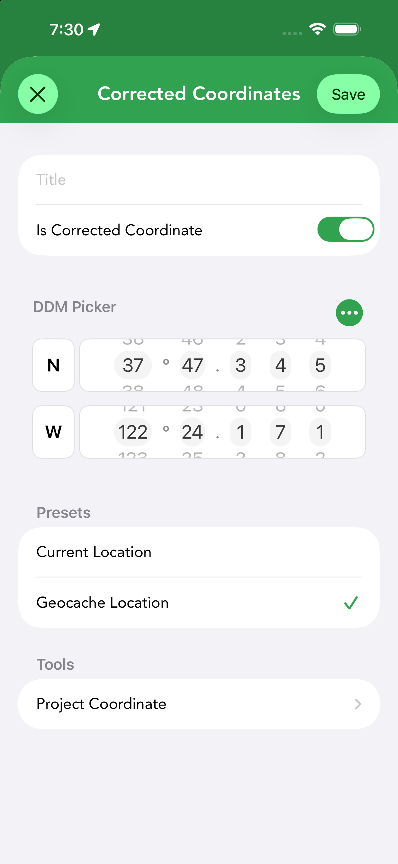
Tap Corrected Coordinates › Add on the detail screen to open the editor:
- Is Corrected Coordinate — the toggle that marks the entry as the cache’s corrected location.
- Coordinate entry — a DDM picker by default; the format menu switches between DDM Picker, Degrees Decimal Minutes, Decimal Degrees, Degrees Minutes Seconds and Plain Text, and offers Current Location, Copy and Paste. The same menu appears in coordinate editors throughout Cachly.
- Presets — fill in your Current Location or the Geocache Location as a starting point.
- Tools — Project Coordinate computes a point from a distance and bearing.
Additional Information
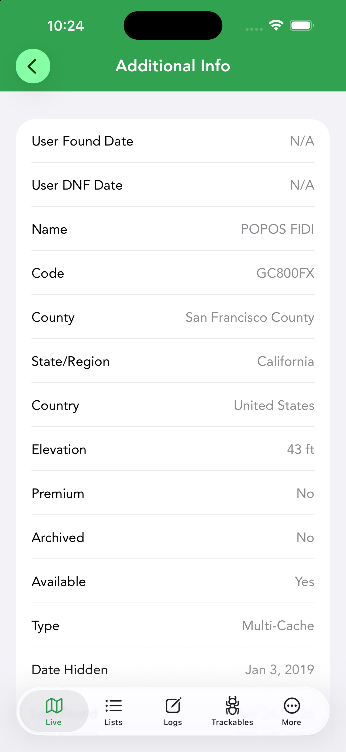
The Additional Information screen at the bottom of the details list collects everything else about the cache in one table: your found and DNF dates, the name and code, the owner (as well as who placed it), county, state/region and country, elevation, container size, favorite points, whether the cache is premium, archived or available, its type, difficulty and terrain, the date hidden, the date published (when the reviewer released the listing — often later than the hidden date, and the date that matters for FTF races and “new caches” challenges), the last found date, the cache’s coordinates in decimal, DDM and UTM, and the listing URL. Some fields load on demand: tap Elevation to fetch it, and for offline caches the county is filled in manually (a Cachly Pro offline-list feature) rather than automatically.
Found but Not Logged
If you log a find but save it as a pending log or draft rather than posting it, the cache is marked Found but not Logged — a checkmark on the map pin and list icon so you can see at a glance that you’ve found it but haven’t finished the log.
Buttons & Menus
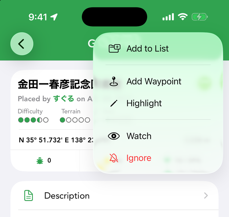
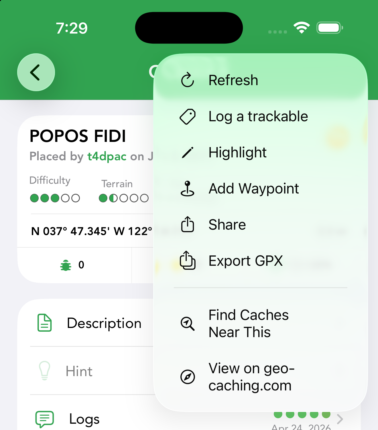
A floating bar along the bottom of the detail screen holds the two buttons you use most. Log Geocache opens the logging flow; once you’ve logged the cache the button switches to a checkmark with Found (or Attended for events) and the date. If you have unsent pending logs for this cache, a small options button appears at the right end of Log Geocache — tap it for a View Pending Logs menu listing each one (tagged with the account name when you log for several users). The round compass button starts navigation; on a Wherigo cache it opens a menu instead, with Download Cartridge (opens in the official Wherigo app) and Navigate to Cache.
The top bar has two menus. The + menu is for things you add or apply to the cache; items you’ve already applied switch to their Remove counterparts:
| + menu | What it does |
|---|---|
| Add to Calendar | Events only — creates a calendar entry for the event (see below). |
| Add to List | Save the cache to an offline list. |
| Add Waypoint | Create a user waypoint (incl. projection). Premium members see it on every cache; Basic members on offline caches. |
| Highlight | Set the cache’s color highlight. On a highlighted cache this becomes Edit Highlight and Remove Highlight. |
| Add to County Finds PRO | Credit a found cache’s county toward your county-finds totals (countries with county data only). |
| Favorite | Award the cache a favorite point (Premium members, found caches, not events). Remove Favorite takes it back. |
| Watch | Add the cache to your geocaching.com watchlist (not shown on caches you own). |
| Ignore | Add the cache to your geocaching.com ignore list (not shown on caches you own). |
The ⋯ menu holds everything else, in three groups:
| ⋯ menu | What it does |
|---|---|
| Refresh | Re-download the cache’s data. |
| Log a trackable | Log a Travel Bug / geocoin against this cache. |
| Export GPX | Export the cache to a GPX file. |
| Find Caches Near This | Search for caches around this one. |
| View on geocaching.com | Open the listing in the browser. |
| Load Full Cache | Basic members only — fetch the full listing instead of the lite data Basic members get by default. |
| Edit | Offline caches only — edit the cache’s details. |
| Delete | Offline caches and caches in online lists. On a cache saved in several offline lists, Delete opens a submenu with Remove From List (this list only) and Delete From All. |
| Share | Share the cache via the iOS share sheet. |
Add to Calendar (events only) opens a New Event sheet pre-filled from the listing — the event title, location (its coordinates), all-day start/end dates, the event-page URL and the description as notes. Edit anything you like and tap Add; Cachly asks for Calendar permission the first time.
Creating an Offline Geocache
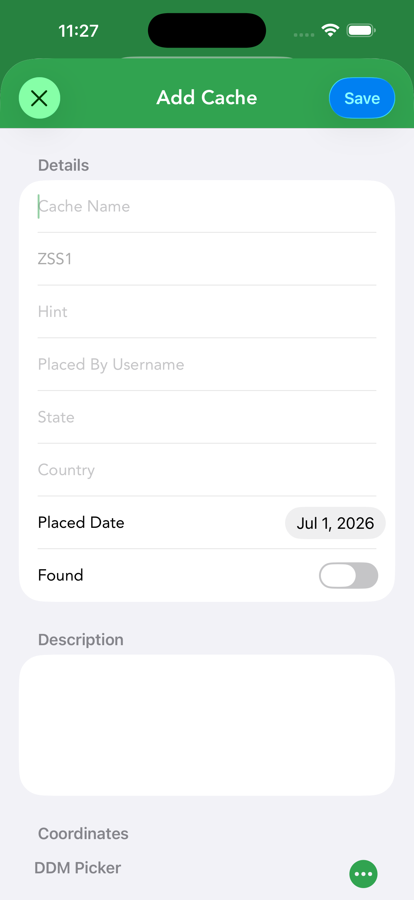
Cachly can also create a cache entry from scratch — useful for hides you’re planning, caches from other listing sites, or waypoint-style targets you want to treat as a full cache. Choose Create Offline Geocache from an offline list’s ⋯ menu, or from the menu of a dropped pin to start it at that spot. The new cache is stored in the offline list like any other, so you can navigate to it, add waypoints and log it.
The editor covers everything a real listing has:
- Details — cache name, cache code, who placed it, the Placed Date, and a Found toggle.
- Description — free-form listing text, plus a hint.
- Coordinates — the standard DDM picker with the same coordinate-format menu (DDM, Decimal Degrees, DMS, Plain Text, Current Location, Copy, Paste).
- Type — pick any cache type.
- Difficulty and Terrain — sliders from 1.0 to 5.0.
- Size — the container size.
- Options — Available, Archived and Premium toggles, plus state and country.
Tap Save to add the cache to the list; you can Edit it later from its detail screen’s ⋯ menu. This is also how you plan a hide: draft the cache and its coordinates here, then copy the details over to Geocaching.com’s Hide a geocache page when you’re ready to submit it.